An unexpected architectural tradition linked many Olmec and Maya societies of Mesoamerica, an ancient cultural area that ran from central Mexico to Central America.
Starting as early as around 3,400 years ago and for roughly the next two millennia, those communities constructed ceremonial centers based on a common blueprint. That plan was grounded in ideas about space, the calendar and possibly beliefs about the universe, researchers report October 25 in Nature Human Behavior.
An airborne remote-sensing technique called light detection and ranging, or lidar, revealed 478 rectangular and square ceremonial centers across Mexico’s southern Gulf Coast, over an area roughly the size of Ireland. Lidar maps detected remnants of ceremonial centers dotting the landscape in an Olmec homeland area and stretching westward around 500 kilometers to the Maya lowlands, say archaeologist Takeshi Inomata of the University of Arizona in Tucson and his colleagues.
Olmec society dates from around 3,500 to 2,400 years ago. Its relation to later Maya culture is unclear, although Maya and Olmec people may have influenced each other’s cultures between 3,000 and 2,800 years ago, Inomata suspects.
“The discovery of standardized [ceremonial] complexes across this broad area, many of them having rectangular shapes, forces us to rethink what was happening during this period,” Inomata says. A continuous 2,000-year tradition of ceremonial complex construction now appears to have characterized Mesoamerican settlements of various sizes and political arrangements.
New lidar data from so many Mesoamerican sites “reveals an astonishing reality — the sheer vastness of what we didn’t know about the emergence of urbanism in this part of the world,” says archaeologist Francisco Estrada-Belli of Tulane University in New Orleans, who was not part of Inomata’s team.
Although ground surveys and excavations of lidar-detected sites are in the early stages, many probably date to between 1050 B.C. and 400 B.C. Inomata’s team has surveyed 62 sites in a western portion of the lidar-mapped area and excavated five of them.
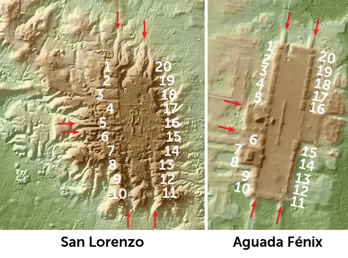
In a major revelation, lidar data detected a previously unrecognized ceremonial space at an early Olmec settlement called San Lorenzo. Dating to between 1400 B.C. and 1150 B.C., this area consisted of 20 rectangular earthen mounds bordering a large, rectangular plaza.

San Lorenzo’s ceremonial center provided the original framework for corresponding constructions at later sites, Inomata’s team says. Until this discovery, San Lorenzo’s layout had been viewed as different from all other sites in the region.
Later complexes included rectangular or square plazas surrounded by 20 mounds. That number probably represented the base unit of Mesoamerican calendars, which were used to organize ritual activities, the scientists say. Some centers were built along an east-to-west axis that aligned with the sunrise on ritually important days of the year.
A site previously excavated by Inomata and his colleagues contains the largest rectangular ceremonial complex discovered so far. Aguada Fénix in the western Maya lowlands features an elevated, rectangular plateau that measures about 1,400 meters long and nearly 400 meters wide (SN: 6/3/20). That site dates to around 3,000 years ago.
Frequent contacts among diverse societies across the region resulted in the initial spread of the San Lorenzo ceremonial blueprint and the adoption of a sequence of four variations on that theme over the next 2,000 years, Inomata’s team suggests. Shared ceremonial center configurations appeared despite differences in Mesoamerican political systems. For instance, colossal head sculptures at San Lorenzo and another Olmec center, La Venta, reflect the presence there of class systems run by kings and a ruling elite. But other sites with ceremonial centers, including Aguada Fénix, show no signs of ruling classes or marked social inequality.
Innovations in building ceremonial complexes appear to have emerged elsewhere possibly by around 100 years after San Lorenzo got the ball rolling, Estrada-Belli says. Around 3,000 years ago, for instance, structures that lidar data indicate were added to the basic ceremonial configuration at Aguada Fénix, as well as architectural twists originating at several other Gulf Coast sites, began spreading to other parts of the region, he says. Inomata’s lidar evidence “shows that San Lorenzo was one of multiple places of monumental architectural innovation.”
So many commonalities link the newly identified ceremonial complexes across Mexico’s Gulf Coast that it’s hard to sort their builders into different cultures, says archaeologist Robert Rosenswig of the University at Albany in New York, who did not participate in the lidar study. “It would be realistic to refer to them all as Olmec, especially as the architecture of Maya in Guatemala and Belize seems to be quite different,” he says.
Lidar surveys are uncovering shared architectural designs, layouts and orientations across other Mesoamerican regions, adds Rosenswig, who wrote a commentary that accompanies the study in Nature Human Behavior. Rosenswig has contributed to research documenting such consistencies in a network of city-states on the Pacific coast of southern Mexico, Guatemala and El Salvador that flourished between around 2,800 and 2,100 years ago (SN: 7/29/18).
"many" - Google News
October 25, 2021 at 10:00PM
https://ift.tt/3GmXPzM
Lidar reveals a possible blueprint for many Olmec and Maya ceremonial sites - Science News Magazine
"many" - Google News
https://ift.tt/2OYUfnl
https://ift.tt/3f9EULr

No comments:
Post a Comment