While record amounts of rain have greatly reduced the risk of wildfire in some Northern California regions, the southern reaches of the state are not so lucky. Southern California anticipates the return of dangerous fire weather for the Thanksgiving holiday.
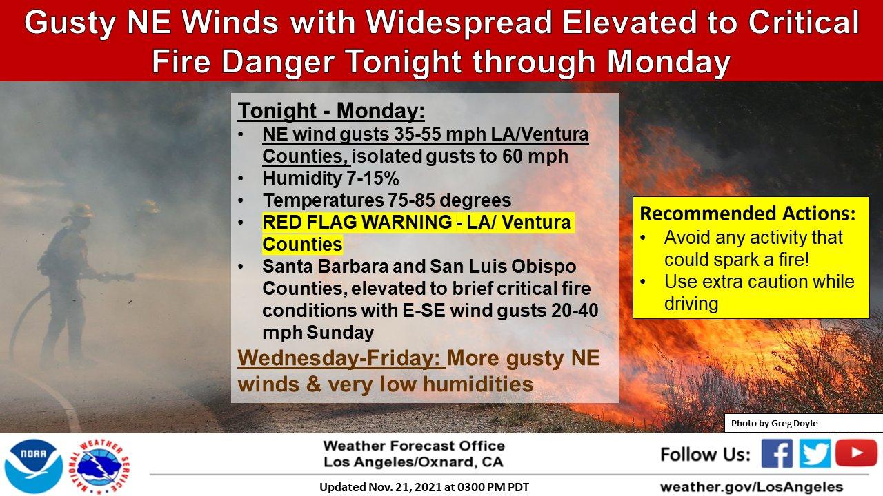
Residents of Los Angeles and Ventura counties have been on alert since early Sunday when strong Santa Ana winds began battering the region with warm, dry gusts. While the winds were forecast to diminish by Monday afternoon, the National Weather Service foresees the Santa Anas will return Wednesday and last through the end of the week.
“That is the busiest travel day of the year,” said Rich Thompson, National Weather Service meteorologist at the Los Angeles-Oxnard station. “Many people will be traveling up Interstate 5. There could be sparks from cars and trucks. It’s something we’re watching.” Sparks from vehicles are often the cause of fires that start in dry brush, with sparks carried on the wind to spread the flames.
Southern California didn’t receive the type of storm that brought significant amounts of rain to the San Francisco Bay Area in October.
The atmospheric river flooded low-lying streets throughout the Bay Area, bringing swift relief to a region under threat from wildfires for many months. Rick Canepa, a National Weather Service meteorologist for the region from the Central California coast to the greater Bay Area, said the storm brought enough moisture to the vegetation to lessen the threat a wildfire would spread with the out-of-control force that can gain power in parched conditions.
“We’re not anticipating any fire weather concerns in this part of California — in the Bay Area and North and Central coasts,” Canepa said. “It’s because of the large amount of rainfall we got so early in the season.”
The October storm brought notable amounts of rain, especially to the North Bay.
Santa Rosa recorded 15.39 inches of rain from Oct. 1 to Nov. 21 — the most ever recorded for that time period going back to 1902 when record-keeping began.
Rain levels were also high in downtown San Francisco with 8.32 inches during that period, which is 296% normal for those dates, according to Canepa. Oakland International Airport recorded 6.21 inches since Oct. 1, which is 296% of normal.
Thompson warned drivers to be vigilant when traveling south.
“This is Santa Ana season. It’s typical to get these strong northeasterly winds,” Thompson said. “But because we only had only a little bit of rain in October, the vegetation is still very dry, critically dry.”
Julie Johnson is a San Francisco Chronicle staff writer. Email: julie.johnson@sfchronicle.com Twitter: @juliejohnson
"danger" - Google News
November 22, 2021 at 11:30AM
https://ift.tt/3nCyaMe
Fire danger lingers in Southern California, lacking downpours that hit Bay Area - San Francisco Chronicle
"danger" - Google News
https://ift.tt/3bVUlF0
https://ift.tt/3f9EULr
No comments:
Post a Comment