- An outbreak of severe thunderstorms will impact the South through Thursday.
- Tornadoes, damaging winds and large hail are the expected threats.
- Long-track intense tornadoes are possible.
A dangerous tornado outbreak is underway in the Deep South, including the potential for long-track intense tornadoes as well as damaging winds and large hail. There will be a continued threat of widespread severe storms across the Southeast into Thursday.
NOAA's Storm Prediction Center (SPC) issued its highest threat level forecast for severe weather, called a "high risk", from parts of the lower-Mississippi Valley into Alabama. High-risk severe weather forecasts are rare and the last one to be issued was in May 2019.
Be sure you have multiple ways to receive severe weather warnings if you are at risk of seeing severe storms. This could include a NOAA weather radio or your smartphone.
Latest Reports
-Barry and Stone Counties, Missouri: Barns destroyed, grain silo downed near Galena. Damage to homes near Elsey and Wheelerville.
-Billingsley to Clanton, Alabama: Damage reported to structures, including homes from one tornado just before 1:30 p.m. in Billingsley. A second tornado was sighted by spotters from a separate supercell at 5:03 p.m. and damaged homes near Pooles Crossroads and structures near Clanton.
-Choctaw County, Alabama: Four homes damaged in Silas; tornado continued into Marengo County, damaging one mobile home.
-Heavy rain triggered flash flooding in parts of Cullman and Lauderdale Counties, Alabama, closing some roads. Over 4 inches of rain triggered a small rockslide near Guntersville.
-Streets were flooded and closed in Jonesboro, Arkansas. Several vehicles were stranded, requiring water rescues.
NOAA's Storm Prediction Center has issued a number of tornado watches across the South.
Some of these are "particularly dangerous situation" tornado watches, a type of tornado watch rarely issued and means strong tornadoes are possible.

Current Radar, Watches and Warnings
(Watches and warnings are issued by the National Weather Service.)Below is the latest forecast showing what areas could be hardest hit by severe thunderstorms and when.
Forecast
Wednesday Night
Widespread severe thunderstorms are likely into the overnight hours across the South, particularly from the lower Mississippi Valley eastward to western Georgia. Some areas like Mississippi and Alabama might see multiple rounds of severe storms.
(MORE: Why Nighttime Tornadoes Are So Dangerous)
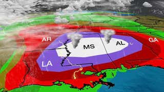
Supercell thunderstorms could produce long-track intense tornadoes, especially in the high-risk area shaded white in the map below from northeast Louisiana into central and southern Mississippi and central Alabama.
However, the threat of dangerous severe storms capable of producing strong tornadoes, large hail and widespread damaging winds is expected in a broader area of the South. This includes much of Arkansas, Louisiana, Mississippi, Alabama, southwest Tennessee and western and central Georgia.
Some of the cities that could see damaging storms are Monroe, Louisiana; Jackson, Mississippi; Memphis, Tennessee; and Birmingham, Alabama.
Localized flash flooding is also a potential threat in the South.

Wednesday-Wednesday Night Severe Thunderstorm Forecast
(Shaded on the map above is the likelihood of severe thunderstorms, according to NOAA's Storm Prediction Center. Note that not all categories apply for the severe weather risk on a particular day. )Thursday-Thursday Night
A line of strong to severe storms will be ongoing early Thursday morning from around the Appalachians to portions of Georgia, eastern Alabama and the Florida Panhandle. These storms might pose a risk of damaging wind gusts and some embedded tornadoes, including around the Atlanta area.
The risk of severe weather will spread as far east as the central and eastern Carolinas, eastern Georgia, southeastern Virginia and northeast Florida later in the day into the early evening. Widespread damaging winds, large hail and several tornadoes are possible.
Some of the cities that could see damaging storms are Columbia and Charleston, South Carolina; Raleigh and Charlotte, North Carolina; Norfolk, Virginia; and Savannah, Georgia.

Thursday-Thursday Night Severe Thunderstorm Forecast
(Shaded on the map above is the likelihood of severe thunderstorms, according to NOAA's Storm Prediction Center. Note that not all categories apply for the severe weather risk on a particular day. )What You Can Do To Stay Safe
Here are some practical steps you can take to be ready for severe storms.
-Before severe weather strikes, know where to seek shelter so you can get there quickly, even in the middle of the night. This is particularly important if you live in a mobile home. You probably will need to leave a mobile home for either a community storm shelter or another building.
-Take every forecast, watch or warning about severe weather seriously, particularly if it is forecast overnight. It only takes one tornado or severe thunderstorm capable of, for example, downing a tree on your home, to pose a danger.
-As mentioned earlier, be sure you have multiple ways to receive severe weather watches and warnings. This could include a NOAA weather radio or your smartphone, which can sound an alarm to wake you at night when a severe weather alert is issued for your area. These alerts could provide the precious minutes needed to move quickly to shelter and may save your life.
Recap
Here are some other notable reports from the outbreak.
-Moundville, Alabama: 20 to 30 homes and businesses damaged; large tornado then moved into southern Tuscaloosa County skirting the southeast side of Tuscaloosa.
-Jefferson County, Alabama: Tornado was reported on the west side of the Birmingham metro area, near Birmingport, early Wednesday afternoon. That was followed by a second tornado in the town of Oak Grove, which then tracked toward Brookside and Gardendale.
-Bluffton, Alabama: Four structures were damaged by an apparent tornado.
-Wayne County, Mississippi: Damage was confirmed to homes and chicken houses.
-Four separate tornado-warned supercell thunderstorms tracked near or over Selma, Alabama, from Wednesday afternoon into early Wednesday evening.
-Lines of severe thunderstorms produced a 59 mph wind gust in Jackson, Mississippi, and downed trees and power lines in the Baton Rouge, Louisiana, metro area.
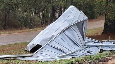
This tin roof was blown off a building by severe winds in the Woolworth community in northeast Lincoln County, Miss., Wednesday, March 17, 2021. Forecasters believe more severe weather is expected Wednesday with the potential for massive tornadoes, downpours and hail the size of tennis balls. (Brett Campbell/The Daily Leader)
The Weather Company’s primary journalistic mission is to report on breaking weather news, the environment and the importance of science to our lives. This story does not necessarily represent the position of our parent company, IBM.
"danger" - Google News
March 18, 2021 at 03:43AM
https://ift.tt/3vD6atN
'Particularly Dangerous Situation': Tornado Outbreak Continues in the South; Damage in Mississippi, Alabama | The Weather Channel - Articles from The Weather Channel | weather.com - The Weather Channel
"danger" - Google News
https://ift.tt/3bVUlF0
https://ift.tt/3f9EULr
No comments:
Post a Comment